Sunday, 26 July 2015

Flora and Fauna: Part II - Day 12 - 26 July 2015

This morning we got a early start on the trail because we didn't need to drive all the way from Ottawa. It was humid, but overcast so thankfully not too hot. After taking a wrong turn at the very start of the trail, we found the trail and headed on our way along the edge of a fallow field. Happily though, after not long, we ended up going along the Tay Canal Tow Path. The Tay Canal is connected to the Rideau Canal which allowed waterway access to the town of Perth. The Tow Path followed right alongside the Tay Canal and was used back in the olden days by horses to pull boats along the Tay Canal (I read an info sign to learn all that)

Tay Canal. It was so humid it was almost misty.

Delightful mowed Tow Path. Thanks to the Town of Perth for maintaining the trail!
It was a really nice peaceful walk along this path with easy footing which we much appreciated so that our somewhat sore legs and feet could warm up and get the kinks out! We saw a few blue herons, but they took off before I could get a photo and we also came upon a deer, which also ran off before I could get a photo.

More mowed path alongside a field :-). Normally we would have to walk through the tall grass. 

Along the path we came upon this little snake, Rolla was in front and narrowly avoided stepping on it!
The path then took us right into the town of Perth alongside the canal. We came upon this swing bridge and were very lucky to arrive right when a boat was coming through so we got to see it swinging open. The lockmaster guy told us that it only opens 2 or 3 times a year because not many boats go this way. It was amazing to see, the lockmaster was able to move the bridge all on his own by inserting a specially bent pipe into the bridge and then pushing it around in a circle. I thought I had taken a video of it opening, but guess I pushed the wrong button my camera because I only have a photo. You can kinda see the guy on the bridge and that the bridge has moved a few feet. It was super cool to see this!


The town of Perth was very pretty and quaint. It seemed to be a lot more prosperous than the town of Smiths Falls which was just down the road and which we had walked through during our last hiked. We enjoyed our time at the pub last night it was pretty walk through town today. The trail passed through this picturesque park in downtown Perth


And here you could see the evidence of the torrential rain the night before with giant puddle in the park


This day we were doing the hike north to south so that when we finished, we could just drive north to pick up the other car and be on our way back to Ottawa. That meant however, we had to follow the trail descriptions backwards which is always a challenge. This proved to be very difficult to do in Perth and we ended up losing our way and had to take a bit of a detour to end up back on the Rideau Trail (I had to resort to using google maps on my cell phone to figure out our route). The difficulty with the Rideau Trail maps is that in the towns, the scale is too large on the map to show the street names, so it is difficult to navigate, especially when you have to read the description backwards!

Once we got back on track, we went through really nice recreation grounds that had covered picnic tables!

Rolla enjoying the luxurious picnic tables
Unlike the trails I'm used to hiking that have nice rest stops along the way, the Rideau Trail is often in a mosquito infested swamp or forest or alongside a road, so there aren't often nice places to stop and eat/rest. More often than not we finish our hike sore and tired because we've only taken 1 or 2 quick stops, so we really appreciated this nice stop!

After the trail left town, it went though fields and forest along a well-kept track. Thank you to the Rideau Trail Central Club which is based out of Perth for the trail maintenance! It was so nice not be walking on an overgrown trail!

We saw this deer and two fawns (hiding in the grass behind mamma deer).


We were pretty tired for the hike after our long hike the day before but once we got into it and found our rhythm, it went well. We found that our legs and feet fatigued way more quickly but overall we felt good for day two of hiking.  It was so nice to have a well maintained trail too!

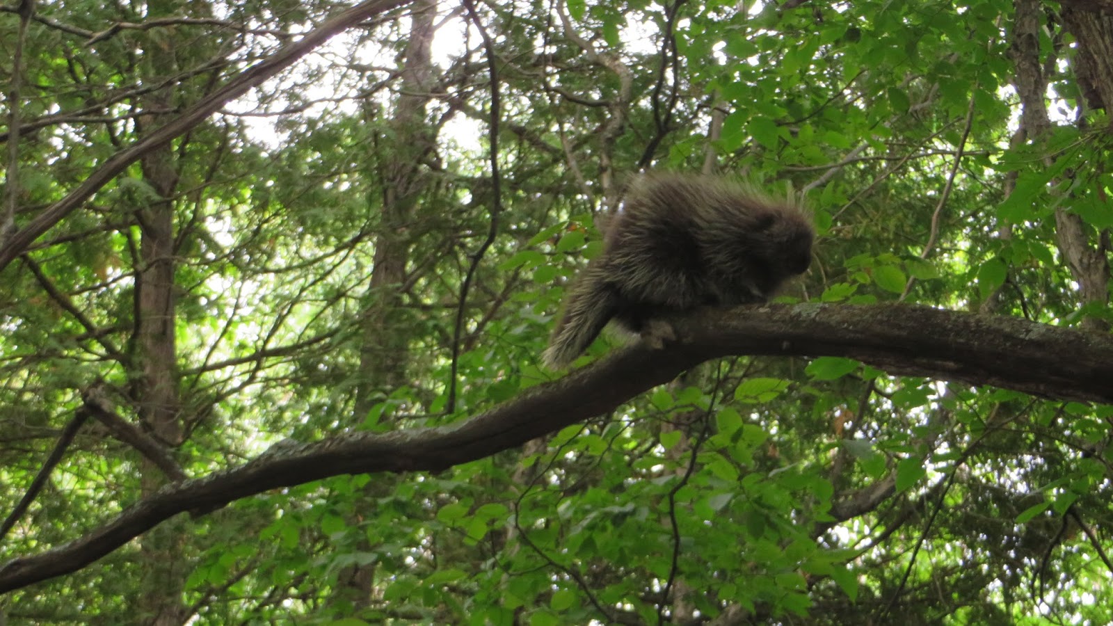
We finished midday and then drove back to Ottawa. Happy but tired after a good weekend of hiking with a few unexpected adventures!  It was nice to see some animals and flowers along the trail, which the first we had really seen.  I'm looking forward to see how the landscape changes as we head further south.

Happy trails!


Statistics:
Start Point -11A
End Pont - 10B
Time - 4 hours 
Daily Distance - 14 km
Total Distance - 173.1 km (we think we might be halfway! There are 19 maps and we've completed almost 11.  I've read that the trail is 305 km not counting the blue side trails or 387 km with the side trails, but I'm not quite certain if those totals are correct. Time will tell!)
Lesson Learned: Be more diligent at route planning when we go through a town next time, especially if we're going "backwards" from the trail description! 

Flora and Fauna: Part I - Day 11 - 25 July 2015

After a less than enjoyable experience our last day on the trail, we hoped that this weekend the Rideau Trail would redeem itself. It had lots of opportunity, since we would be hiking two days in a row. Our route started at 9B in Murhpy's Point Provincial Park and then went to 10B. This would leave a gap between 10B and 11A (where we had started our last hike) that we would do the next day because it was closer to Ottawa, so it would be a shorter drive home. Since we're getting farther away and because we were staying the night in Perth, the logistics of car pick-up and drop-offs were complicated and confusing, but we figured it out!

We dropped a car at 10B and drove south to Murphy's Point Provincial Park. The Rideau Trail goes through the Park, so you need a Park Pass to park in the parking lot. I had carefully chosen our route to take us to the Southern edge of the Park where the trail parking lot was. I figured there would be a park office on the southern entrance to the park where we could buy a pass. Wrong! We ended up having to drive all the way north through the park and then went to the park store to buy a pass only to be told that the store didn't sell park passes, only the campground registration office did. So we had to drive further to the campground to buy a park pass. We were not impressed. But eventually with pass in hand we returned to the parking lot, ready to hit the trail.

We were wearing long sleeves and long pants due our past experiences with overgrown trails. I was happy we were properly attired when I saw this sign in the trailhead parking lot!

I sure don't want to contract Lyme Disease!

Rideau Trail sign in Murhpy's Point Provincial Park. Look at that lovely trail!
We were delighted to be hiking on a real trail (not overgrown!) and there was a cool breeze and no bugs for the first while. It was wonderful! The Rideau Trail had already redeemed itself!

The trail went through a lovely forest
Before we knew it, we left the Provincial Park and entered private land and were greeted by this sign!

Good thing it wasn't fall time!
The next section of trail was through some really nice land with rolling hills and rock outcroppings. The geography was very different here than anywhere farther north on the Rideau Trail. We very much enjoyed the cool breeze and interesting terrain. However, it was relatively slow going because the trail twisted and turned, but wasn't actually an obvious trail (the lovely mowed grass trail ended part way through the Provincial Park), so we spent a lot of time trying to find the next orange triangle marker every time we entered or exited a clearing or stand of trees.

After a few kilometres we passed over a stile and entered the Mica Mines Conservation Area.


This is a stile, used to climb over a fence. We often pass over at least 5 of these each day. 
The picture doesn't show it very well, but this was typical topography of the area, with a small hill. This was the first time we saw hills on the trail! I think this is because we are starting to enter the Frontenac Arch area which is section of the granite Canadian Shield that protrudes in the area (see, I did learn something in undergrad geology class!). It was so nice to be walking through different terrain (ie. not swamp!)

Hill! And close by was a granite outcropping
 We continued through this pretty landscape and saw some pretty flowers (a first for our hike!)


Yes, it's a thistle, but it was very pretty!
Then we came upon these little friends up in a tree.

Mama porcupine on the trunk of the tree (centre) and baby on the branch (left)

The baby was on guard making cute little squealing sounds and raising its quills
Due to our late start and the rain that had started falling we decided to take the final section of the trail on the road rather than on the trail (through a swamp, but the trail description said there was a boardwalk. I didn't trust it). We followed blue arrows for the first time (blue arrows mark side trails from the main Rideau Trail).

Blue Arrow!
It was raining lightly which was pleasant because it was a pretty hot day (the cool breeze has stopped hours before). However, the final section on the road felt long (but I'm sure the trail, likely wet, muddy and overgrown would have felt even longer!)

It's hard to stay motivated walking along a gravel road for almost 10 km. We ended up counting telephone poles to pass the time
But we did see some pretty cows along the way!

Not sure if they were highland steer, but they did have hair in their eyes
At the very end of the hike it started to rain hard, so we ended up getting pretty wet!

Gators kept the bottom of my pants dry, but the rest of me was soaked!
We drove back to Perth (where we stayed for the night), got cleaned up, dried off and went to a lovely pub for supper and watched a spectacular thunder and lightening rainstorm. It went on for about 2 hours, with pouring rain, huge lightening and loud thunder. We were sooo happy to be inside enjoying a pint and not camping! (we had considered the idea of camping at Murhpy's Point, but decided that a real bed and shower would be nicer!)

It was a really nice day out hiking. The Rideau Trail definitely redeemed itself even though there was lots of road walking at the end (but the final few kms of that was our decision). With all the rain we were hoping that the trail wouldn't be too wet for the next day of hiking.

Statistics:
Start Point -9B
End Pont - 10B
Time - about 5 hours
Daily Distance - 18.9 km
Total Distance - 159.1 km
Lesson Learned: Even the best Rolla and Zuzka plans can fall through (arg, Murphy's Point Provincial Park) and you can start hiking an hour later than planned!


Sunday, 12 July 2015

Back At It! Day 10 - 11 July 2015

Our 2015 hiking season started off later than anticipated in part due to our busy schedules and also because of the wet spring we had. I knew that the trail would be water-logged in the spring, so I was hoping that it would be drier in July.  In spite of our late start, the plan is to do the remainder of the trail, all the way to Kingston this year. 

We started early in the morning since the temperature was supposed to reach 30 degrees Celsius in the afternoon. We walked a section of the trail that was more or less west to east, leading us into the town of Smiths Falls. This is the Kingston to Ottawa direction of the trail and the trail description are written this way, so it's way easier to navigate hiking this way. It proved to be a good decision because the trail was difficult to find in a number of sections.

Start of the 2015 hiking season

We set off along a dirt road, which quickly turned into an overgrown track. As usual. Look below.

Rolla on the "Trail"
If it were not for the orange triangle trail markers nailed to trees and posts, we would never find our way. The trails are quite often overgrown so that you have to walk through tall grass. For only the 2nd time we lost our way on (the first time was in Marlborough Forest when we didn't turn where we were supposed to). This time though was different, because we crossed on a stile over a fence and then couldn't find a trail marker anywhere to indicate the direction we should travel and of course there was no actual trail to follow. After about 10 minutes of wandering around the area we eventually saw a trail marker and continued on our way. A little frustrated, but I wasn't ever concerned because we knew exactly where we were, we just couldn't determine which way to go!

I was thinking that the Rideau Trail should actually be called the "Rideau Route" because there definitely is a route that you follow, but we haven't been on many actual trails through the woods and the rest of the route makes use of roads and highways.

Early on in the day we had to walk through a very wet swamp. The water was so deep it went over both our boots so walked the rest of the day with very wet socks and boots. 

The section of the trail that we did today consisted of overgrown tracks and walking along highway 43.

Hwy 43. It was actually really busy with lots of traffic.
The bugs were really bad in the bush and it was slow going due to the poor trail condition, so we were actually happy to get out on the highway where there was a breeze and a wide, smooth gravel shoulder to walk on. It is nice for the sections of bush and highway to be broken up because it offers a change of pace.

After another section of bush and then more walking on the road we made it to Smiths Falls. After going through residential neighbourhoods the trail went along the Rideau Canal following a lovely park.

Rideau Canal in Smiths Falls


We finished our hike in the parking lot where we had finished our hiking last fall. It's a parking lot at the town's recreation grounds with soccer and baseball fields and also docks into the canal. There is also a needle drop box. This was our point of reference as we had remembered seeing it there last year. Who knew Smiths Falls had such an IV drug use problem?!


Today was our first hike of the year we hiked our longest distance yet. The last 5 kms were pretty painful and it was very hot, but I'm glad we got it done! As usual, the cool drinks we had kept in a cooler in the car were very refreshing and we were able to dangle our feet in the water off the dock which was heavenly! Thankfully in spite of our wet socks and boots we faired pretty well. Rolla's feet were pretty painful at the end though and the muscles in my hips and lower back were sore and fatigued at the end, but overall not bad all things considered.


Statistics:
Start Point -11A
End Pont - 12C
Time - 5 hours 
Daily Distance - 20.2
Total Distance - 140.2 km
Lesson Learned: Pack an extra pair of socks in case your boots get flooded early on in the day!


Sunday, 2 November 2014

30 Seconds of Faith - Day 9 - 1 November 2014


Since we have made it so far along the Rideau Trail, it now takes just under an hour to get to our starting point on the Rideau Trail. With the longer drive we make sure to hike long enough to make the drive worthwhile, so we are consistently doing 17km sections. Today's section of the trail took us from the middle of nowhere, west into the town of Smith's Fall. We figured that we even though we would be ending our day on pavement it would be nice to finish in a town.

With the forecast for rain turning into snow, I wasn't sure how the day would unfold, but thankfully there was no precipitation of any kind and in spite of a chilly wind, it was quite a nice day for hiking. The trail started on a gravel road, then turned into a a dirt track, back onto gravel roads and then most of the day was on paved roads. While we were on the dirt track, it was really nice. We were sheltered  from the wind and with most of the leaves gone from the trees we were afforded a good view through the forest. We heard a few gunshots, as it was the first day of the deer hunting season, but they were relatively far away and we were wearing bright orange, so still felt safe. Along the gravel roads, we passed by some pretty farms though and came upon this horse with beautiful pinto colouring.


Walking along the paved roads isn't really our favourite thing to do and the Rideau Trail follows many more kilometeres of pavement than I had anticipated. We try to make the best of it even though it's not particularly pleasant or interesting.

The long, straight, paved road ahead
We stopped for a snack on the patch of grass under this farm's sign. The house wasn't very far away, so I'm sure the people who lived there were wondering what on earth we were doing!
Rolla enjoying lunch - and sporting her bright orange NDP toque :-)
Along the way we saw a sheep farm. Those are the first sheep we've seen along the way!


We've been seeing these hearts and arrows spray painted along some of the paved roads the last few times we've been out.

My friend Lucy rode her bike across Canada this summer and also noticed these same type of spray painted hearts and arrows on roads in Quebec. My guess is that they mark the way for one of those charity bike rides for the Heart & Stroke Foundation or something. It's funny that we're seeing them here in Eastern Ontario and she saw them near the Gaspé Peninsula in Québec!

The Rideau Trail took us right through the town of Smith's Falls where we passed what was once a Hershey's chocolate factory, part of which is now being used by a company called Tweed to grow medical marijuana.
The writing at the bottom of the sign says "Here's to Future Growth"

While walking past this building we were downwind and there was a very strong marijuana smell - there were houses very close by, so I can't imagine what it would be like to live there smelling that all the time!

The last 300 metres of the trail were by far the nicest of the day. There was a narrow path that led us down to the shore of the Rideau Canal.


There was a park with a picnic table (yay!) where we stopped for one last snack and the timing was perfect to see a Via Rail passenger train to go over the railway bridge over the Rideau Canal.


The trail then led us up through the locks, which had a pretty significant drop, so it was impressive to see them empty

Looking back at the railway bridge and along the canal where we had come from
Zuzka at the locks.

Rolla ready to climb up the steep stone stairs.

Add caption

Walking along the top of the closed lock was a bit unnerving because it was such a long drop to the bottom of the empty lock below
On the other side of the locks there was a small park and we couldn't tell which way to take, but we knew that Rolla's car was parked just on the other side of the Rideau River, so we went in the direction we thought was right. Sure enough, after crossing the park, we found a narrow trail and a Rideau Trail marker.

The trail is very well marked, but sometimes there are only trail markers after an intersection, thankfully though it is usually quite obvious at the intersection which way to go. This does create a few moments of uncertainty where Rolla and I always remark to each other "do you think is this the right way? Have you seen a trail marker?" But sure enough a few moments later we are always relieved to see a little orange triangle attached to a tree, post or even painted onto a wall. I keep reminding myself that I just need 30 seconds of faith before I question the route we have taken because inevitably a trail marker will appear within 30 seconds. I've been thinking that perhaps having an extra 30 seconds of faith in something, or someone, is a good lesson for life and not just for hiking the Rideau Trail. ... profound thoughts for a blog about hiking! 

Since we were quite chilled when we finished our hike, we stopped at the Tim Horton's in Smith's Falls for some soup and tea to warm us up. We have decided to change from having gatorade at the end each hike to having tea. The cooler weather has arrived!

Statistics:

Start Point - Intersection of Burchill and McConnell Roads
End Pont - 12C
Time - 4 hours 
Daily Distance - 17 km
Total Distance - 120 km
Number of dogs that barked at us as we walked past along the road - at least 5


Tuesday, 14 October 2014

Century Celebration! - Day 8 - 13 October 2014

Thanksgiving Monday seemed like an auspicious day for a hike, so we set out for our 8th day of hiking on the Rideau Trail - wondering what type of adventures the trail would bring us!  We started in the middle of nowhere, parking at the intersection of two gravel roads and immediately headed into the the forest on a disused road (well maybe used by people riding ATVs). It was a lovely fall morning, chilly and clear, with many leaves on ground and some still in the trees. The track was dry (!!) and it was lovely walking.

Carpet of leaves covering the track

Not far along we crossed this pretty creek (we would cross this creek two more times throughout the day. This section of trail did not take a very direct route!)

Creek crossing #1 (thankfully there were bridges each time!)
The trail followed old roads/tracks for about 7 km through beautiful fall forest. Unlike last time, we were prepared for hunting season, wearing bright colours, but we didn't hear a single gunshot although we did see a sign that said "caution active hunting in area". I was sure glad I had a neon orange hat on and a neon yellow and orange vest on covering my pack.

Rolla and Zuzka rockin' the high visibility colours. Safety first! 
The Rideau Trail then led us to a secondary highway where we walked along the shoulder. After only a kilometre or so, we entered Merrickville. The first proper town we've been to along the way!


  Merrickville is a quaint historic town with locks along the Rideau Canal. There was once a mill on the Rideau River adjacent to the Locks, which is now a historic site. The entire Rideau Canal is a Parks Canada National Historic Site and we were delighted to have our morning lunch (we usually eat two small lunches) at this beautiful location at the Merrickville Locks National Historic Site. It was so nice to eat at a proper picnic spot - and such a beautiful one too!

Best lunch location yet!

Parks Canada Adirondack chairs were very much appreciated!

View from the chairs
After our break, we crossed the river and then walked along the actual Rideau Canal locks. I took lots of photos for my Dad :-)


Inspiration for our next adventure? Canoeing the Rideau Canal and portaging the locks...
Rolla walking alongside the Merrickville Locks

Open lock
Looking up at a closed lock

Almost empty lock
 
The following 9.3 km were all along roads. While it was a beautiful day, walking along the side of a paved road with no shoulder, facing oncoming traffic isn't that pleasant. I find it's hard on my knees and hips walking on the pavement and Rolla finds her feet don't appreciate the hard pavement either. I was impressed though that most of the oncoming traffic gave us lots of space and pulled into the other lane. When they did this, I made sure to give them a wave and smile in appreciation. As we have yet to meet any other hikers doing the Rideau Trail, I wonder if the locals are used to seeing hikers along that stretch of road or if we looked out of place! 

We walked under a train bridge and not long after, a train went over it and I managed to catch this photo of it passing. It's kind of hard to see, but there are two engines on the bridge!


About 3 km from the end was another set of locks with a picnic site and this was within a few hundred metres of our 100 km mark, so we took this opportunity for a much needed rest, our second lunch and a celebration of the "century" (100 km) that we had walked! I figured pink champagne was exactly what we would need to mark the occasion, along with some fancy cookies from my favourite bakery.

Pouring the champagne. Rolla couldn't believe I had carried that all day. It was totally worth it :-)

Champagne and leaf-shaped decorated cookies (camouflaged in with real leaves!)

Woohoo, we've walked 100 kms! 1/3 of the way to Kingston!
We finished off the final few kilometres of the day with me guessing that we would arrive in Burritt's Rapids (where we had parked Rolla's car) "just after the next straight section" or "just around the next curve". After a few iterations of this, it was finally true and we came to the car, a bit sore after all the pavement walking but still in good spirits :-)

Statistics:

Start Point - Intersection of Burchill and McConnell Roads
End Pont - 14A
Time - 4 hours 20 minutes
Daily Distance - 17.3 km
Total Distance - 103 km
Number of moquitoes - zero!
Number of woolly bear caterpillars we saw on the side of the road - countless!
Volume of pink champagne drank - 200 ml.